Plan Overview
The Dubuque Regional Bike and Pedestrian Plan will help the Dubuque region and its communities improve their trails, on-road bike routes, sidewalks, and pedestrian crossings. The plan maps out a general strategy for future bike and pedestrian network development and identifies specific projects that can be constructed to expand and enhance the existing network.
Final Approved Plan
The final plan was adopted by the Regional Planning Affiliation 8 (RPA 8) Policy Board on June 22, 2023 and the Dubuque Metropolitan Area Transportation Study (DMATS) Policy Board on July 13, 2023. The plan includes information about the Dubuque region, related plans and policies, existing conditions, community input, future network concept, bike and pedestrian projects, facility selection, facility design, facility maintenance, funding programs, and resources. The plan also includes a list of future projects that will address safety issues, expand the bike and pedestrian network, and remove barriers to walking and biking. Click below to view the approved plan, appendix, and interactive project map.
Final Plan
Plan Appendix
Interactive Map
Planning Area
The planning area includes all of Dubuque County and the Dubuque metropolitan planning area. The area includes all cities in Dubuque County, Iowa, the City of East Dubuque, Illinois, and the communities of Sandy Hook and Kieler in Wisconsin. Below is a map of the planning area.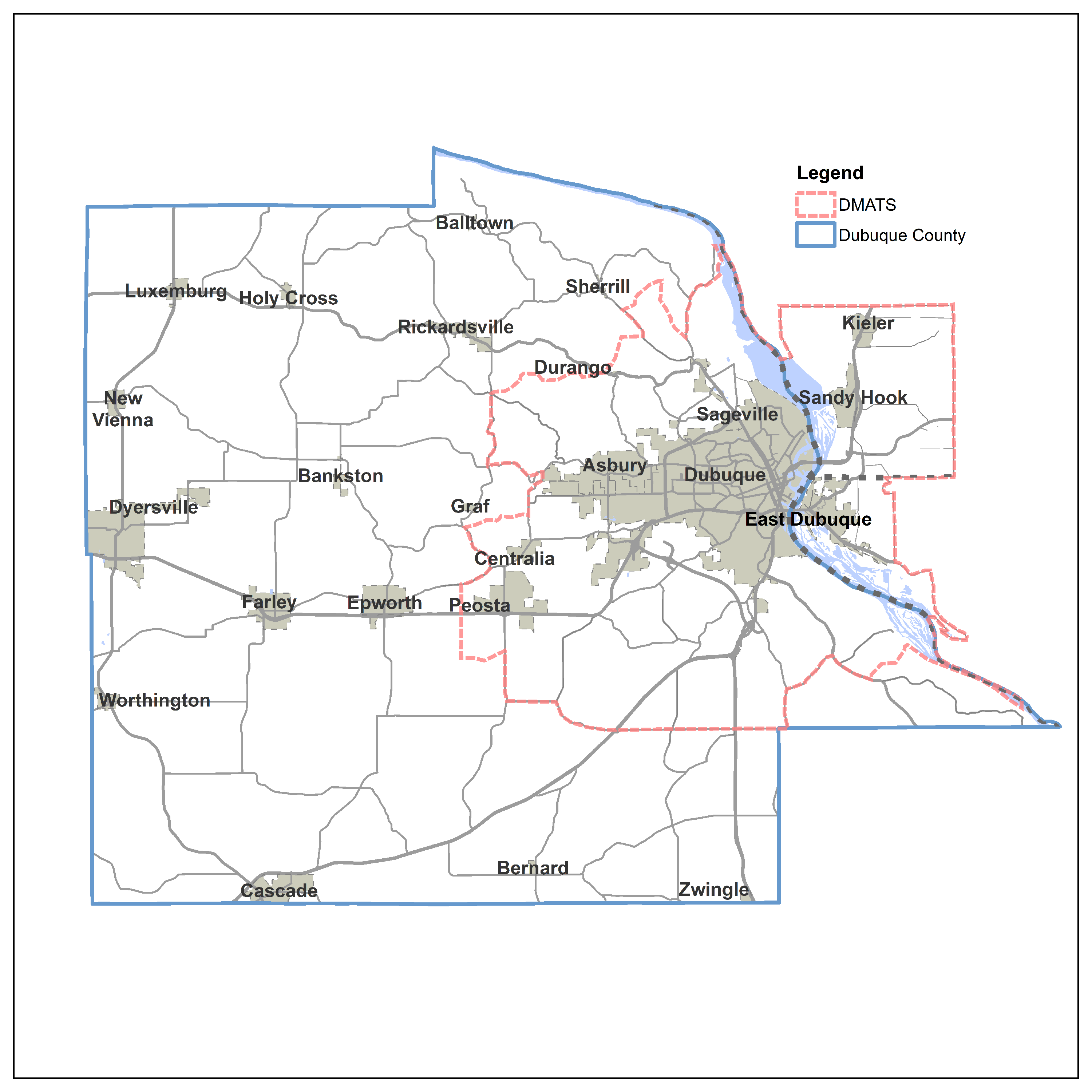
Planning Process Overview
The primary tasks of the planning process were:
- Review Related Urban and Rural Plans, and Federal Policies and Programs
- Review Conditions of Existing Facilities
- Develop a Concept for the Future Network
- Encourage Community and Stakeholder Engagement
- Revise Concept based on Community & Stakeholder Input
- Finalize the Future Network Plan
As part of the process, a Steering Committee was formed with local representatives from Dubuque County, City of Dubuque, City of East Dubuque, Regional Planning Affiliation, Dubuque Metropolitan Area Transportation Study, and Travel Dubuque (representing advocacy groups for tourism and trails).
Community Input
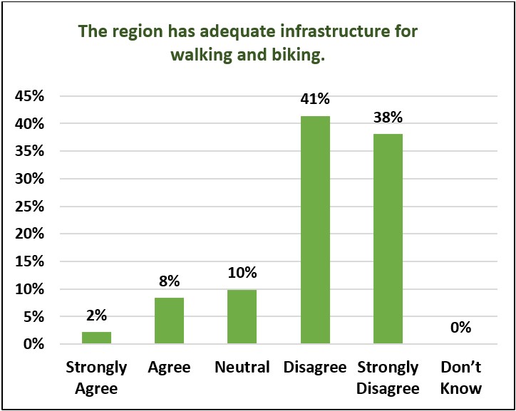
The plan was tested with stakeholders, advocacy groups, community members, and the general public using a project website, an online interactive map, an online community survey, local map displays, and two public input meetings. ECIA received positive comments on many of the region's individual bicycle and pedestrian facilities. But, when asked about the system overall, the feedback was more negative and indicated that there is more work to be done (see chart below).
Click here for the complete results of the bike and pedestrian community survey.
Tri-State Community Needs
Based on community input, the following tri-state community needs are ranked for our elected representatives to give the most weight when choosing the bicycle and pedestrian network projects to fund. 1 = Most important to consider, 8 = Least important.
- Create an integrated bike and pedestrian network to encourage: recreation, wellness, transportation, energy conservation, tourism, environmental education, air quality, personal financial savings, and transit ridership.
- Connect the regional bike and pedestrian network to state, county, and city recreation areas such as along the Heritage Trail and Southwest Arterial, on both sides of the Mississippi River, and at the Field of Dreams Movie Site.
- Provide safe and comfortable connections from neighborhoods to educational institutions, parks, employment, shopping, places of worship, entertainment, and other points of interest.
- Provide connections to regional, state, and national trail systems, including the Heritage Trail and the Mississippi River Trail (MRT).
- Provide safe, paved multi-use trails with restrooms, benches and bike racks linked to a corresponding website and maps.
- Advocate for adoption, strengthening, and implementation of “Complete Streets” policies by cities and counties in the Tri-State area.
- Encourage walking and biking safety education for all road users, and enforcement of traffic laws to improve safety.
- Improve clarity of route options for residents, tourists seeking to visit the area, and bicyclists passing through.
Priority Goals for Future Network
Based on community input, the following priority goals are ranked for our elected representatives to give the most weight when choosing the bicycle and pedestrian network projects to fund. 1 = Most important to consider, 8 = Least important.
- Develop a connected bike and pedestrian network close to all residents
- Improve bike and pedestrian safety and comfort
- Increase Complete Streets with safe access for all people who need to use them and Safe Routes to School for children to walk and bike
- Link the bike and pedestrian network, public transit, and automobile facilities to foster multi-modal travel
- Connect residents and tourists with services and destinations
- Use consistent street, wayfinding, trail, and map signs
- Educate all users in safety and rules of the road
- Improve multi-modal access and mobility
Priority Routes for the Future Network
Community input helped identify Priority Routes using existing and future bike and pedestrian facilities. Below is the map of the Priority Bike and Pedestrian Routes..jpg?t=202304201142020)